Odisha Map with District: Navigate Seamlessly with Our Map Of Odisha State
Odisha Map With Districts in Odiya Language
Discover the beauty of every district, from the capital city Bhubaneswar to the cultural hub of Cuttack. Our maps provide an intricate overview, guiding you through the dynamic landscapes of Puri’s coastal serenity and the culturally rich tribal regions. If you’ve been using the term ‘map of Orissa,’ we’ve covered you with the most updated and comprehensive maps, reflecting the transition to Odisha.
Whether planning a route, studying geography, or simply curious about the state’s topography, our Odisha state maps offer precise details, ensuring an enriching experience. Our maps spotlight the attractions that make Odisha a unique destination, from historical landmarks to cultural gems.
Embark on your Odisha journey with Odipedia, where every line on the map unfolds a story of heritage, culture, and natural beauty. Let our maps be your digital compass, guiding you seamlessly through the treasures of Odisha. Start your exploration today with Odipedia’s Odisha state map – your gateway to the heart of this enchanting region.
Explore Odisha: District-wise Maps
As you know there are 30 districts in Odisha. Let’s explore each district’s map views.
Anugul District Map

Angul, spanning around 6,070 square kilometers, is known for its industrial prowess and scenic landscapes.
With a diverse population, the district is a melting pot of cultures and traditions.
Approx Population: 1,273,184
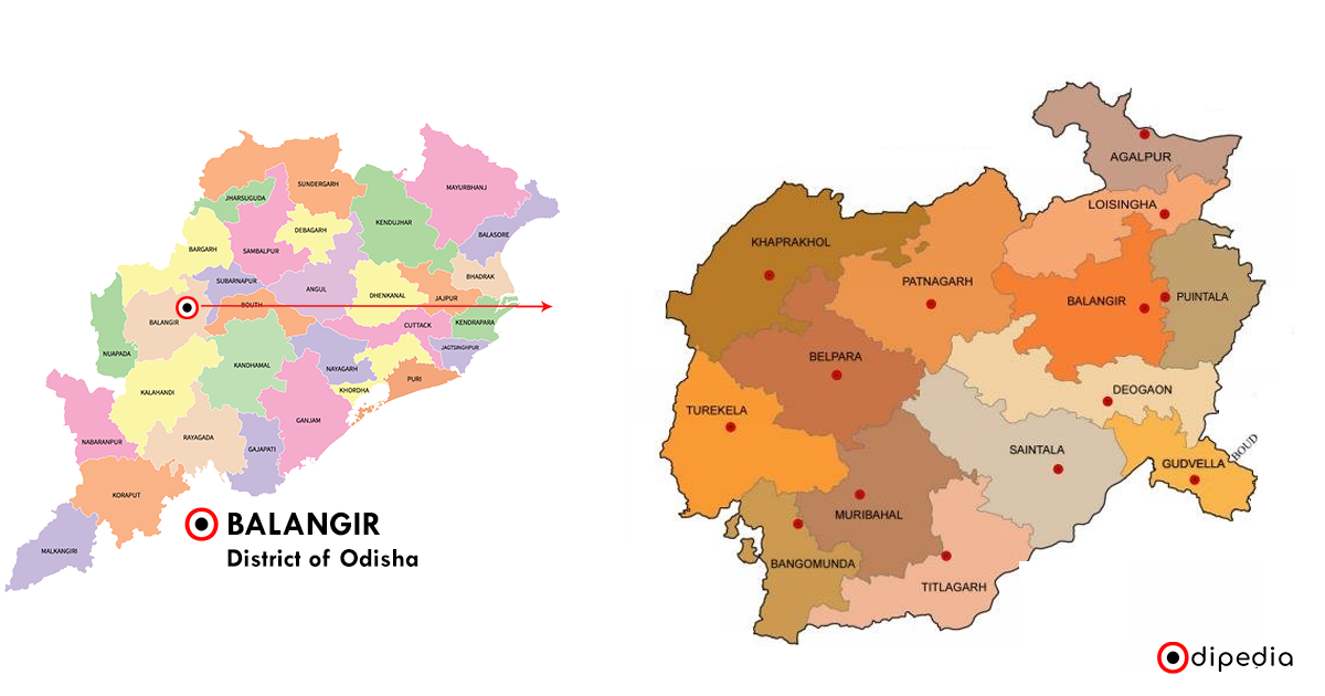
Balangir District Map

Balangir, covering an area of approximately 6,575 square kilometers, boasts a rich cultural heritage.
As one of the largest districts, it is characterized by its expansive landscapes and historical significance.
Approx Population: 1,648,997
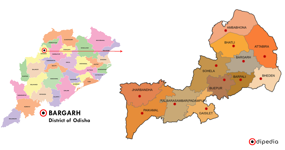
Bargarh District Map

Bargarh, encompassing about 5,837 square kilometers, is a vibrant district celebrated for its festivals and craftsmanship.
Its diverse topography adds to the charm of this culturally rich region.
Approx Population: 1,481,255
Bhadrak District Map

Bhadrak, extending over 2,505 square kilometers, is a coastal district with a significant maritime influence.
The district combines a bustling urban center with the tranquility of its coastal areas.
Approx Population: 1,506,522
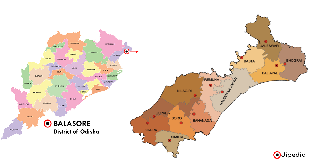
Balasore District Map

Balasore, with an area of around 3,634 square kilometers, is a coastal delight.
Known for its beaches and scientific establishments, the district is a harmonious blend of natural beauty and technological advancements.
Approx Population: 2,321,546
Boudh District Map
Boudh, spanning approximately 3,098 square kilometers, is characterized by its serene landscapes and historical importance.
The district offers a glimpse into Odisha’s cultural and spiritual heritage.
Approx Population: 439,917
Cuttack District Map
Cuttack, covering about 3,932 square kilometers, is a bustling urban district steeped in history.
Known for its ancient monuments and vibrant markets, Cuttack is a hub of cultural and economic activities.
Approx Population: 2,618,708
Deogarh District Map
Deogarh, with an area of around 2,781 square kilometers, is a picturesque district nestled in the hills.
Known for its scenic beauty and cultural heritage, Deogarh offers a tranquil escape.
Approx Population: 312,164
Dhenkanal District Map
Dhenkanal, extending over 4,597 square kilometers, is a district with a rich industrial and cultural heritage.
The district seamlessly combines modernity with a connection to its historical roots.
Approx Population: 1,192,948
Gajapati District Map
Gajapati, covering approximately 3,056 square kilometers, is a district surrounded by hills and dense forests.
Known for its tribal communities and natural beauty, Gajapati is a haven for those seeking tranquility.
Approx Population: 577,817
Ganjam District Map
Ganjam, spanning around 8,070 square kilometers, is the most populous district in Odisha.
Known for its vibrant culture and diverse landscapes, it offers a mix of coastal beauty and historical significance.
Approx Population: 3,529,031
Jagatsinghpur District Map
Jagatsinghpur, covering an area of about 1,668 square kilometers, is a coastal district with a rich maritime heritage.
Its proximity to the Bay of Bengal influences both its culture and economy.
Approx Population: 1,136,604
Jajpur District Map
Jajpur, encompassing approximately 2,899 square kilometers, is a district steeped in history and religious significance.
Known for its ancient temples and archaeological treasures, Jajpur attracts pilgrims and history enthusiasts alike.
Approx Population: 2,609,267
Jharsuguda District Map
Jharsuguda, extending over 2,081 square kilometers, is an industrial hub with a dynamic landscape.
Known for its coal mines and power plants, the district plays a crucial role in Odisha’s economic development.
Approx Population: 701,872
Kalahandi District Map
Kalahandi, with an area of around 8,364 square kilometers, is a district known for its cultural diversity and natural beauty.
Home to several tribal communities, Kalahandi preserves a rich tapestry of traditions.
Approx Population: 1,576,869
Kandhamal District Map
Kandhamal, spanning approximately 7,640 square kilometers, is a district nestled in the Eastern Ghats.
Rich in biodiversity, the district is known for its lush greenery, indigenous communities, and unique traditions.
Approx Population: 804,121
Kendrapara District Map
Kendrapara, covering an area of about 2,644 square kilometers, is a coastal district known for its mangrove forests and thriving biodiversity.
The district is a haven for nature enthusiasts and birdwatchers.
Approx Population: 1,440,361
Kendujhar (Keonjhar) District Map
Kendujhar, with an area of around 8,249 square kilometers, is a mineral-rich district known for its mines and lush landscapes.
The district’s iron and manganese reserves contribute significantly to Odisha’s economy.
Approx Population: 2,137,515
Khordha District Map
Khordha, extending over 2,888 square kilometers, is home to the capital city, Bhubaneswar.
The district is a blend of urban development, historical monuments, and religious sites.
Approx Population: 2,251,673
Koraput District Map
Koraput, covering approximately 8,807 square kilometers, is a district known for its tribal communities, scenic landscapes, and cultural vibrancy.
The district reflects the rich heritage of Odisha’s hinterlands.
Approx Population: 1,379,647
Malkangiri District Map
Malkangiri, spanning around 5,791 square kilometers, is a district located in the remote areas of Odisha.
Known for its tribal communities and lush greenery, Malkangiri offers a glimpse into a more secluded way of life.
Approx Population: 613,192
Mayurbhanj District Map
Mayurbhanj, covering an area of about 10,418 square kilometers, is the largest district in Odisha.
With a diverse topography, it is known for its forests, waterfalls, and cultural heritage.
Approx Population: 2,513,895
Nabarangpur District Map
Nabarangpur, encompassing approximately 5,291 square kilometers, is a district characterized by its tribal culture and scenic landscapes.
The district is known for its unique traditions and natural beauty.
Approx Population: 1,220,946
Nayagarh District Map
Nayagarh, with an area of around 3,890 square kilometers, is a district known for its historical significance and vibrant rural life.
The district offers a mix of cultural heritage and natural attractions.
Approx Population: 962,215
Nuapada District Map
Nuapada, extending over 3,853 square kilometers, is a district with a diverse cultural tapestry.
Known for its tribal communities and historical relics, Nuapada showcases the rich heritage of Odisha.
Approx Population: 608,382
Puri District Map
Puri, covering approximately 3,479 square kilometers, is a coastal district famous for the Jagannath Temple.
With its pristine beaches and religious significance, Puri is a major pilgrimage and tourist destination.
Approx Population: 1,697,983
Rayagada District Map
Rayagada, with an area of around 7,073 square kilometers, is a district surrounded by hills and forests.
Known for its indigenous communities and natural wonders, Rayagada reflects the tribal heritage of Odisha.
Approx Population: 967,911
Sambalpur District Map
Sambalpur, spanning approximately 6,702 square kilometers, is a district known for its industrial development and scenic landscapes.
The district combines modernity with a connection to its historical roots.
Approx Population: 1,045,660
Subarnapur (Sonepur) District Map
Subarnapur, covering an area of about 2,337 square kilometers, is a district with a rich cultural heritage.
Known for its festivals and historical significance, Subarnapur offers a blend of tradition and modernity.
Approx Population: 761,659
Sundargarh District Map
Sundargarh, extending over 9,712 square kilometers, is a district known for its mines, tribal communities, and natural beauty.
The district’s landscapes range from forests to plateaus, offering diverse attractions.
Approx Population: 2,093,437


